YOUR TRUSTED PARTNER FOR ALL YOUR GRADING, EXCAVATION, AND RAIL MAINTENANCE NEEDS.
Cronin Civil & Rail uses GPS machine control, drone surveying, 3D site modeling, and fleet telematics on active civil construction projects.
Buying a drone and posting aerial footage doesn’t make a contractor tech-forward. We use GPS machine control, drone surveying, 3D site modeling, and fleet telematics as active project tools on every job that warrants them.
The result is tighter grade accuracy, fewer survey delays, better earthwork planning, and real-time visibility into equipment performance. For you, that means less rework, fewer surprises, and a project that moves the way it was planned.
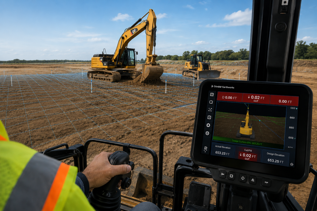
Grade control used to mean a survey crew staking the site, an operator cutting to the stakes, and a superintendent checking the work. Then the survey crew comes back, checks the grade, and restakes where the tolerances are off. That cycle repeats until the grade is right. It costs time on every pass.
Our excavators and dozers run GPS grade control systems. The operator sees real-time grade information on an in-cab display referenced directly to the design surface. They cut to elevation accurately on the first pass without waiting on a survey crew to verify and restake.
On large earthmoving projects, the time savings compound quickly. Fewer survey visits, tighter tolerances, and significantly less overcut and fill. We have seen grade control cut grading time by 20 to 30 percent on complex cut-and-fill operations.
Overcut costs money twice. You pay to remove the material you cut too deep, and you pay again to bring in fill to bring the grade back up. Grade control reduces both. For owners and GCs managing tight budgets on large earthwork scopes, that is a direct line-item savings.
A site walk tells you what you can see from the ground. That is useful. It is also incomplete. Grade changes, volume discrepancies, and surface conditions that matter to the project do not always show up on foot.
We fly drone surveys before, during, and after construction. Pre-construction flights produce accurate topographic data that feeds directly into our earthwork calculations and 3D site models. Progress surveys give owners and project managers a current picture of the site without pulling a superintendent off the work for a two-hour walk. Post construction flights document final grades and surface conditions for project closeout.
The output is not just footage. Our surveys produce point cloud and photogrammetric data that integrates with our 3D modeling workflow. Design team, project manager, and field crew all work from the same current site data.
Disputes over existing conditions, final grades, and earthwork volumes are common on civil projects. Drone surveys create a dated, measurable record at every stage. That documentation protects you and it protects us.
Most earthwork problems are predictable. The issue is that most contractors don’t look hard enough at the site before they mobilize. A grade that looks straightforward on a 2D plan can hide significant volume surprises when the actual terrain gets factored in.
When site conditions change mid project, and they do, we update the model and adjust the plan. That keeps the project moving rather than stopping to figure out what the new conditions mean for the schedule and budget.
Every piece of equipment in our fleet runs a telematics system. Location, engine hours, idle time, fuel consumption, and maintenance alerts come back to our operations team in real time. We know where every machine is, how hard it is working, and when it needs service before that service becomes a breakdown.
For you, that means equipment that shows up ready to run and stays that way through your project. Machines that go down mid-phase because of a missed service interval are an avoidable problem. We avoid it.
On larger projects, telematics data gives our project managers visibility into daily production rates and equipment utilization. If a machine is sitting idle when it should be working, we know. If a phase is burning more hours than the estimate projected, we see it early enough to adjust.
A machine that goes down on a critical path activity doesn’t just cost a repair bill. It costs production time, crew standby, and schedule recovery. Telematics keeps our maintenance ahead of failures rather than behind them.
Technology doesn't run a project. Equipment and crew do. These tools exist to make the work more accurate, more predictable, and better documented. We use them where they add real value to the scope, not to check a box on a capabilities list.
If you want to see how any of these tools have been applied on past projects, call us. We can walk you through specific examples from active and completed work.
(724) 947-5215
Select excavators and dozers in our fleet carry GPS grade control systems. Not every job warrants it, but for large earthmoving scopes with tight grade tolerances, it is the right tool. We will tell you upfront which machines are equipped and how we plan to deploy them on your project.
A dated, measurable record of your site at any point in time. Pre-construction, that means topographic data and existing conditions documentation. During construction, it means progress tracking against the plan. At closeout, it means final grade verification. The output integrates with our 3D modeling workflow and can be delivered to your team as a project record.
Yes. The models we build are shareable and can be exported in formats compatible with standard civil design software. If your team is working from a design model, we can work from the same file.
Primarily through reliability and schedule performance. Machines that are maintained based on actual usage data break down less. On larger projects, utilization reporting gives your project manager visibility into daily production and equipment hours against the estimate.
We use them where they make sense for the scope. A straightforward residential site prep job does not need a drone survey or a 3D earthwork model. A large commercial cut-and-fill with multiple phases and a tight schedule does. We will tell you what we plan to use and why before we mobilize.
“The Cronin team was professional, responsive, and highly organized from start to finish. They mobilized quickly, maintained a clean and safe job site, and delivered on every commitment they made.”
— Michael Turner / Owner, Keystone Infrastructure Group
Family owned and operated. Built on hard work, safety, and doing the job right.
We use cookies to enhance your browsing experience, provide personalized content, and improve site performance. For the best experience, please keep your browser up to date — download browser latest.